Davies Creek
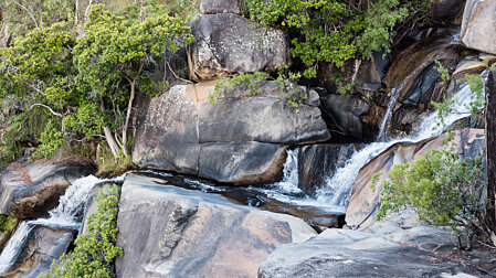
 Cascades & swimming pools above the main Davies Ck falls
The turn off is on the left about 21km past Kuranda and the lower camping area is about 6km along Davies Ck road on the left.
Lower Davies Creek camping area map
You pass the Davies Ck Mountain Bike Park on the way.
Continue on up the hill to the car park on the left just before the gate. The falls are close to the car park but, if you have the time, take the circuit walk because there is a better swimming pool further up with a sandy beach. The view from the falls in the late afternoon is magnificent.
Upper Davies Ck camping area map Davies Ck National Park map
 Top of the main falls
 Cascades above the falls
 Halfway down the falls
 Looking down the falls
 Grass trees
 Grass Tree flowers
 Evening light from Davies Ck falls
Beyond the gate the track leads on for another 6km. From here is one of the best walks in NQ to the highest point in the Lamb Range at Kahlpahlim Rock. The forest is beautiful with many large Kauri Pines. From the rock you can see Lake Morris and Cairns in the distance. The Rock Trail is slightly longer than the Ridge Trail. Round trip walk from the car about 4-5hrs (18km).
 Kahlpahlim Rock from Lake Morris
 Kahlpahlim Rock
 Lake Morris from Kahlpahlim Rock, Lamb Range
North Tablelands Parks & Forests map
Atherton & Evelyn Tablelands Journey Guide
Search:


